Software Catalogue
Browse verified software listings, OEM specifications, and request instant B2B quotations.

WebGis With Mobile Application Software
Geospatial Web and Mobile Solution Some of the workflow developed for Forest Management modules as enterprise web & Mobile application for Forest Departments are listed below. (SAME CAN BE IMPLEMENTED WITH ANY WEBGIS AND MOBILE APPLICATION WITH MODIFICATION.) Forest / Wildlife Offence Reporting Wildlife Sighting & Monitoring Workflow Change Detection of Forest Green cover Workflow Micro Level Watershed Workflow Plantation Monitoring Workflow Forest Fire Module Workflow Joint Forest Management Violation of FCA Act / illegal Mining Workflow Asset / Infrastructure Mapping Workflow Income Generation Workflow Forest Right Act Workflow Dynamic Spatial & non-spatial dashboards, Reports Workflow Brief details of the workflow for State Forest Departments Forest / Wildlife Offence Reporting This is an integrated module that allows officials to capture illegal forest activities like illegal felling, transportation, forest encroachment cases through mobile application and present them through the web application. The module allows to create different reports based on this information and analyse them. The module includes layers such as forest boundary, village boundary, administrative zonation, communications. The module includes several different report generation options through predefined queries. Wildlife sighting & Monitoring module This is an integrated web and mobile application module to monitor animal sightings and man-animal conflict within forest boundaries. The web module gets all the input from the mobile based field application. The web application module includes a marquee that shows number of elephant sightings. Male Sightings, Female Elephants Sightings, & Calf sighting. Using their web-based module for wildlife monitoring, managers and researchers can upload photographs and report information, as well as perform damage assessment and man-animal conflict zonation management. It also includes number of predefined queries to understand the animal sightings and man animal conflict in the state using distribution and dashboarding. Change Detection of Forest Green cover Workflow This module can visualise the various dashboard on the different Forest Management data. Change detection module will showcase the Online NDVI change detection module for forest green cover will generate with user Area Of Interest with complete report. Microlevel Watershed Workflow This module is intended to allow officials to find out suitable zones for watersheds within forest boundary. This application considers parameters like Riparian Zonation, Waterbodies, Forest Boundary, forest boundary map, Watershed, Average temperature map, Average rainfall map. It also includes Slope map and elevation map. Plantation Monitoring Workflow This module is tightly integrated with mobile application to capture nursery details, plantation boundaries and trail of information along with photographs. This application not only allows to integrate plantation boundaries, but also allows to capture nursery plantation details with complete information. In this module, plantations throughout the state can be superimposed on a satellite base map and combined on an interactive dashboard that includes live video feeds via a mobile app and other dynamic plantation status information. Forest Fire Mapping Workflow In this solution, data modelling, watershed extraction, slope generation, vector and other data management are carried out using Hexagon’s technologies Geospatial division. Foresters begin by processing satellite images using ERDAS IMAGINE preparing them for analysis. Next, foresters create complex spatial models using Spatial Modelers. These models are used to perform Forest Cover Change, Forest Encroachment Change, Forest Fire Burnt Area Identification, Forest Density Change, and Water Index studies in their area of interest. Forest department users and citizens can use the web-based geoportal to submit incident reports that include the geographic location of the incident, what type of damage is evident, reporting date and time, and upload photos. Joint Forest Management This is an integrated module that allows microplanning for joint forest management. The module allows to create proposed activities for a JFM boundary. It also allows officials to capture completed activities using the field application. Officials can understand and generate reports using the module the JFM units those have prepared microplan, units those have not prepared microplan and understand the number of JFM activities performed by the administrative zones. The module includes layers such as communication, waterbody, river, forest boundary, admin boundary, temperature & rainfall data, forest cover map, village boundary etc. Violation of FCA Act / illegal Mining Workflow This module is designed to analyse illegal and legal mining activities happening within the forest boundary. The application is integrated with mobile application that allows to capture illegal activities in the forest zonation along with photograph. Also the mobile application helps to periodical check of the boundary violation. Asset / Infrastructure Mapping Workflow This module allows to keep an account of all the Infrastructure Creation activities. The Infrastructure creation form allows officials to drill down to the required region within Forest boundaries and then fill out information about the infrastructure which includes its type, name, area, estimated and actual costs, inspection details and additional details Income Generation Workflow This module allows to understand the forest product and revenue generated from different activities conducted by various departments. The Income generation Input form allows users to enter all the Income details including account details, inspection details, beneficiary details and additional information. All these details are input through highly secure login management system. Forest Right Act Workflow This is an integrated module that allows forest land management under Forest Right Act. The application has been tightly integrated with the field based mobile application to initiate the process of claim by capturing the boundary. The application has detailed rights given from Divisional Officers to higher management. Updates applied on this data is monitored and maintained through a trail. It contains predefined queries that allows to create reports based on category of rights, total area claimed, total approved area. The module contains layer such as Forest Right cases, communication, waterbody, forest boundary, admin boundary, satellite imagery. Dynamic Spatial & non-spatial Dashboards Reports Workflow This Module will allow the department users, all other stakeholders to visualise dynamic dashboards on Forestry spatial & Non spatial data. Users can choose their desired data to visulaise the data in charts & also they can export the results in PDF & Excels. MOBILE APPLICATION FOR THE SAME WEBGIS WAS MADE FOR REALTIME DATA COMMUNICATION

StadAid
StadAid • Reading .STD file and .ANL file to store all data • Part or all of structure can be selected for view • Member, Joint & Element number display • Start and end node identification for members • Local axis display for elements • RCC beam/column design data visualization • Identification of failed/not-designed members • Pile reaction display in tabular format for all loads with marking for capacity failure • Superstructure support reaction displayin tabular format • Load case selection for pile reaction and for RCC design of pile cap • One-way and two-way shear checks for pile caps • Proximity check for piles of adjacent pile caps. • Bending moment and shear force diagram for pile cap Purpose and Integration with STAAD StadAid aims to streamline this workflow. It starts by reading the existing input and output files from STAAD and displays detailed RCC design data on its own intuitive graphical interface, significantly improving productivity and decision-making speed.

ETABS
Completely Customizable Graphical User Interface.ETABS offers a single user interface to perform modeling, analysis, design, and reporting. There is no limit to the number of model windows, model manipulation views, and data views. Utilize Interactive Design Capabilities to Maximize Efficiency Design of steel frames, concrete frames, concrete slabs, concrete shear walls, composite beams, composite columns and steel joists can be performed based on a variety of US and international design codes. Interactive Database Editing CSI software stores model data and other information in database tables which may be edited directly through interactive database editing. This powerful feature allows models to be developed or edited quickly. ETABS offers a wide range of code-based design features for steel frame, concrete frame, cold form steel, and aluminum frame. BIM Interoperability With CSI software, collaboration between different AEC teams is handled efficiently through compatibility with other BIM software.

SAP 2000
STRUCTURAL ANALYSIS AND DESIGN THE INDUSTRY STANDARD FOR STRUCTURAL ANALYSIS The SAP2000 name has been synonymous with state-of-the-art analytical methods since its introduction over 45 years ago. SAPFire® Analysis Engine CSI solvers have been tried and tested by the industry for over 45 years. The SAPFire Analysis Engine can support multiple 64-bit solvers for analysis optimization and can perform both eigen analysis and Ritz analysis. Parallelization options are available to take advantage of multiple processors SAP2000 offers a single user interface to perform modeling, analysis, design, and reporting. The customizable SAP2000 interface allows users to define window layouts and toolbar layouts. DirectX Graphics DirectX graphics have been enhanced for quality and speed. Lightning-fast DirectX graphics with full 2D and 3D drafting and selection capability. DirectX graphics with hardware-accelerated graphics allow for navigation of models with fly-throughs and fast rotations. Sophisticated and efficient meshing techniques Engineers have many options when it comes to mesh generation in SAP2000. Notable meshing features include the ability to merge independently defined meshes among frame, shell and solid objects, coordinate tessellation with object orientation, and observe material boundaries to establish effective aspect ratios. Design Codes SAP2000 offers a wide range of code-based design features for steel frame, concrete frame, cold form steel, and aluminum frame.

SYNCHRO 4D
SYNCHRO 4D is an industry-leading 4D construction modeling, digital planning, and simulation software developed by Bentley Systems. Improve project visibility with 4D Simulate construction sequences, evaluate what-if scenarios, and detect issues early with model-based 4D visualizations. Reduce project risks and costs Identify issues early in a dynamic 4D environment, minimizing errors and rework in the field to improve cost and resource efficiency. Improve stakeholder alignment Align teams with visual reports and simulations that make plans easy to understand, reduce misunderstandings, and support better decision‑making.
PLAXIS 3D
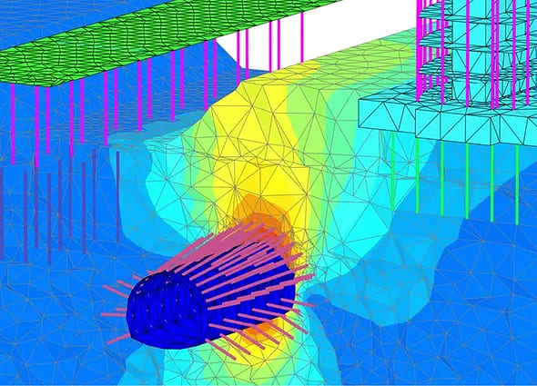
Integrated 3D geotechnical workflows Connect with other software by importing CAD and geological models to support site investigation through advanced 3D analysis. Assess safety with realistic 3D simulation Simulate phased construction and complex 3D ground behavior to predict deformations, assess stability, and reduce project risk.
STAAD FOUNDATION ADVANCED
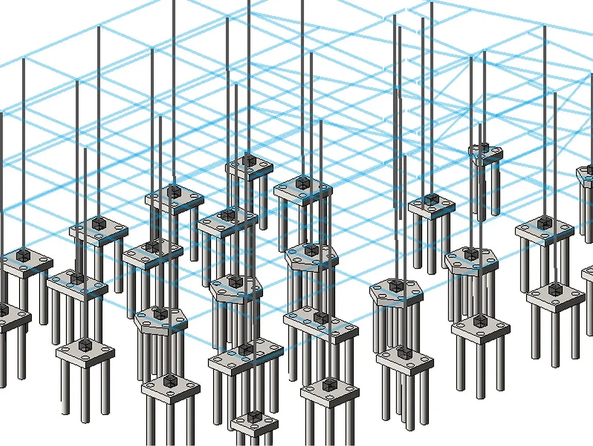
Multiple foundation types in one environment Design isolated, combined, pile cap, and mat foundations within a single foundation design application. Integrate seamlessly with STAAD.Pro Import STAAD.Pro models including geometry, section properties, and support reactions to begin foundation design. Generate detailed drawings and reports Create plan, elevation, and sectional drawings with rebar marks, plus general arrangement drawings with grid lines to identify interferences.

Structural Worksuite
Structural Worksuite Perpetual License
STAAD PRO
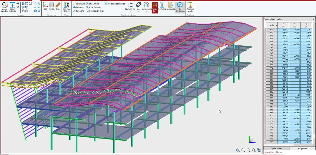
User interface & modeling Quickly build models using structural grids, tooltips, frame generators, and structure wizards. Advanced IDE style editor with IntelliSense, database integration, and context-sensitive help. Analysis capabilities Supports traditional first-order elastic analysis and both large and small P-Delta analysis. Account for imperfections in structural geometry and perform modal time history analysis. Interoperability OpenSTAAD API allows data extraction into custom programs or applications like Microsoft Excel. Export models to ADINA to solve complex nonlinear problems and simplified blast analysis. Integration with CAD platforms.